Back North Warwickshire District CEB Bwrdeistref Gogledd Swydd Warwick Welsh North Warwickshire German North Warwickshire Spanish شمال وارویکشر Persian North Warwickshire French North Warwickshire Italian 노스워릭셔 Korean Ziemeļvorikšīra Latvian/Lettish North Warwickshire Dutch
Borough of North Warwickshire | |
|---|---|
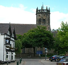
 Atherstone, the administrative centre of the borough and one of the two towns | |
 Shown within Warwickshire | |
| Sovereign state | United Kingdom |
| Constituent country | England |
| Region | West Midlands |
| Administrative county | Warwickshire |
| Founded | 1 April 1974 |
| Admin. HQ | Atherstone |
| Government | |
| • Type | Non-metropolitan district |
| • MPs: | Rachel Taylor Jodie Gosling |
| Area | |
| • Total | 110 sq mi (284 km2) |
| • Rank | 123rd |
| Population (2022) | |
| • Total | 65,946 |
| • Rank | Ranked 288th |
| • Density | 600/sq mi (230/km2) |
| Ethnicity (2021) | |
| • Ethnic groups | |
| Religion (2021) | |
| • Religion | List
|
| Time zone | UTC+0 (Greenwich Mean Time) |
| • Summer (DST) | UTC+1 (British Summer Time) |
| Postcode | |
| ONS code | 44UB (ONS) E07000218 (GSS) |
North Warwickshire is a local government district with borough status in Warwickshire, England. The borough includes the two towns of Atherstone (where the council is based) and Coleshill, and the large villages of Hartshill, Kingsbury, Mancetter, Polesworth and Water Orton along with smaller villages and surrounding rural areas.
The area historically had a large coal mining industry, but the last coal mine in the area, Daw Mill at Arley, closed in 2013.[2] The borough's landscape is primarily of the mildly undulating agricultural variety, with the North Warwickshire plateau rising to 177 m (581 ft) above sea-level at Bentley Common, 2.5 miles southwest of Atherstone. The most significant bodies of water within North Warwickshire are Kingsbury Water Park, Shustoke Reservoir, the River Blythe and the mid-section of the Coventry Canal.
The neighbouring districts are Nuneaton and Bedworth, Coventry, Solihull, Birmingham, Lichfield, Tamworth, North West Leicestershire and Hinckley and Bosworth.
- ^ a b UK Census (2021). "2021 Census Area Profile – North Warwickshire Local Authority (E07000218)". Nomis. Office for National Statistics. Retrieved 5 January 2024.
- ^ "Daw Mill: Hundreds of jobs go at fire-hit mine". BBC News. 7 March 2013. Retrieved 24 December 2018.